

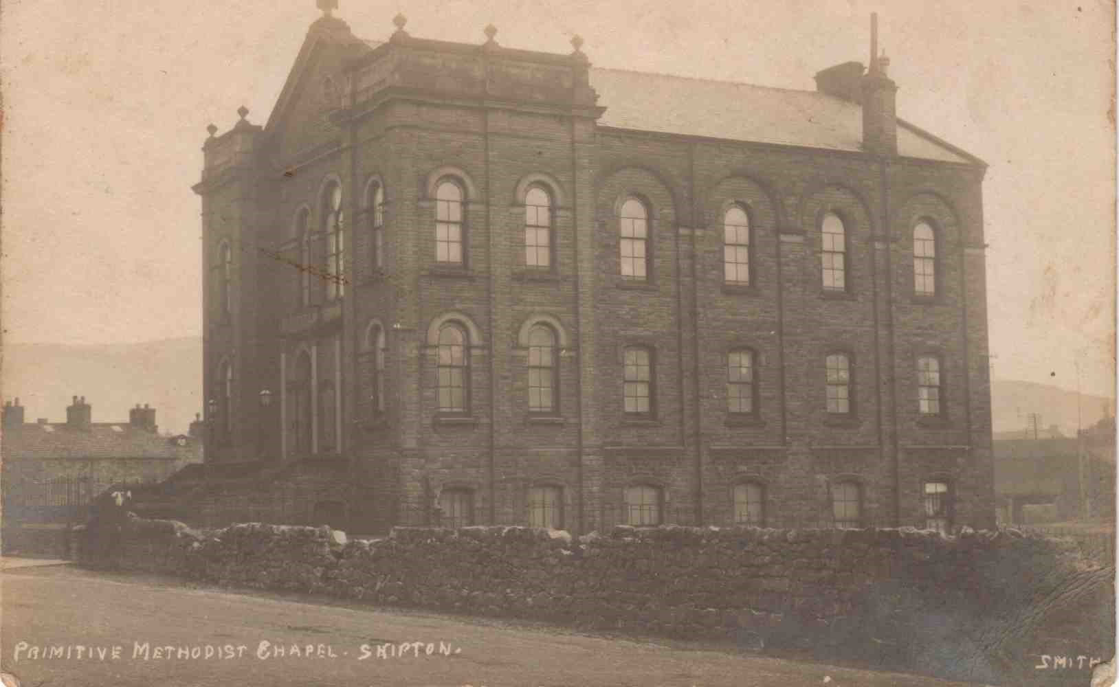
Gargrave Road Primitive Methodist chapel replaced the earlier (1835) Bridge Street chapel in 1878-79. It was a huge building: the Methodist Church Buildings: Statistical returns report that as at July 1st 1940, the chapel seated 700 in pews. There were three schoolrooms and 12 other rooms. The architect was Thomas Howdill of Leeds.
The chapel is shown on the 1891 1:500 OS map and on the 1969-1970 1:2500, but not on the 1979-1986 edition.
An aerial view of chapel
https://britainfromabove.org.uk/en/image/EPW024523
The chapel is towards the top of the picture on the vertical centre-line – it is seen nearly end-on; nearest the camera is its very tall brightly-lit gable-end, to the left of an open space.
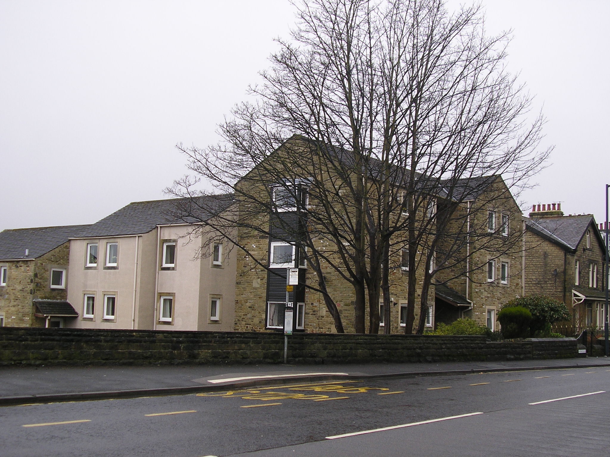
It was demolished in the 1970s and there are now flats on its site
Grid ref SD987517
You can read about the 1835 Bridge Street chapel here.
[editor’s note (CH): Thanks to GW Oxley, Howard Richter and Colin Dews for unscrambling the story of the Skpton chapels. Read the comments here for the full story.]


Comments about this page
The 1879 Primitive Methodist magazine (page 60) contains a note that “the quiet old town of Skipton has had the monotony of its life broken by services in connection with the laying the foundation stone” of a new Primitive Methodist chapel. It would include chapel, school and classrooms and cost £3,000.
Skipton, Gargrave Road PM Chapel. Yorkshire
Grid ref SD987517
In 1940 the chapel seated 700 in pews. There were three schoolrooms and 12 other rooms. The chapel has been demolished and replaced by an apartment block.
Sources
Methodist Church Buildings: Statistical returns including seating accommodation as at July 1st 1940, No 282
Site visit 24.02.2018
More detail and pictures from Howard Richter – thanks Howard.
This is the 1836 chapel, now ‘The Old Fire Station’ on Bridge Street:
https://www.google.com/maps/@53.9616816,-2.0196103,3a,75y,215.39h,94.47t/data=!3m6!1e1!3m4!1szrEx-J6WUBAESY-6KtK8fg!2e0!7i13312!8i6656
and these are the flats on the site of the later, larger, building, on the south side of Gargrave Road.
https://www.google.com/maps/@53.9621764,-2.0211945,3a,90y,195.41h,97.96t/
data=!3m6!1e1!3m4!1sLSqw9IGS6FWsH8d2QYDn6Q!2e0!7i13312!8i6656
Evidence:
1. The 1836 chapel ‘built over a stream’
A building named ’Providence Chapel ’ is shown on the 1856 1:1056 – five feet to the mile – Ordnance Survey map at about SD 9879 5171
https://www.old-maps.co.uk/#/Map/398792/451712/13/100454
This is now the ‘The Old Fire Station’, as shown on the 1989 1:1250
https://www.old-maps.co.uk/#/Map/398792/451712/13/101329
(NB. The Old maps site is no longer freely accessible in 2021)
I suspect that this is the chapel in question because:
1. It is indeed built over a stream, the Eller Beck
2. If I squint, I think I can make out the text ‘Primitive Methodist’ on the 1856 map noted above
3. On the next available OS map – the 1891 1:500, this chapel is not named, and the map shows, only a few yards to the north-west , another PM chapel. This immense building, now vanished, is the one in Mr. Wild’s picture, and is noted below.
Grade II listed
https://www.britishlistedbuildings.co.uk/101316946-fire-street-skipton#.W0aCXLhoemU
Flickr
https://www.flickr.com/photos/rossendalewadey/14421279740
First Streetview. looking south-west
https://www.google.com/maps/@53.9616816,-2.0196103,3a,75y,215.39h,94.47t/data=!3m6!1e1!3m4!1szrEx-J6WUBAESY-6KtK8fg!2e0!7i13312!8i6656
Second Streetview, looking south-of-east
https://www.google.com/maps/@53.9615717,-2.0200646,3a,90y,122.38h,104.23t/data=!3m6!1e1!3m4!1sxf_m7vMUXs08EI3E1N9HWw!2e0!7i13312!8i6656
You note that
The chapel, which was in the Silsden circuit, measured 33′ wide by 56′ long and 26′ high with galleries at each end and on the front side. There were two cottages built under the end galleries
The first Streetview shows one cottage to the left-and-below of the large ‘CAFE’ sign.
The second Streetview shows what I think must be the blocked front-door of the other cottage behind the left-hand green lid. (Note, incidentally, the ‘Weak Bridge’ sign to the left of the bin).
2. The later, larger, chapel, the one in your picture:
This is now flats – on south side of Gargrave Road at SD 9870 5178
The chapel is shown on the 1891 1:500 OS map
https://www.old-maps.co.uk/#/Map/398709/451775/13/100455
and on the 1969-1970 1:2500
https://www.old-maps.co.uk/#/Map/398700/451780/12/100955
but not on the 1979-1986 edition
https://www.old-maps.co.uk/#/Map/398700/451780/12/100956
An aerial view of chapel
https://britainfromabove.org.uk/en/image/EPW024523
The chapel is towards the top of the picture on the vertical centre-line – it is seen nearly end-on; nearest the camera is its very tall brightly-lit gable-end, to the left of an open space.
The 1836 chapel, built over a stream, is now a retail outlet. It was replaced 1878-9 by a chapel by the architect Thomas Howdill of Leeds. It was demolished in the 1970s and there are now flats on its site
Details of an 1835 chapel have been added. What happened to both chapels?
Add a comment about this page