
Thanks to Andrew Radgick, History Officer of The Bracknell Forest Society, for locating the site of the chapel. Andrew reports that the chapel stood on the west side of Green Lane (now renamed Downshire Way). It was located behind the current row of houses named Priestwood Terrace. The adjacent burial ground still exists, albeit behind a five feet fence and very overgrown, at the corner of Downshire Way and Binfield Road.
The chapel appears on the 1909 Ordnance Survey map. On the 1932 map, the chapel footprint is still there, but it is no longer labelled. The burial ground is labelled as “disused”.
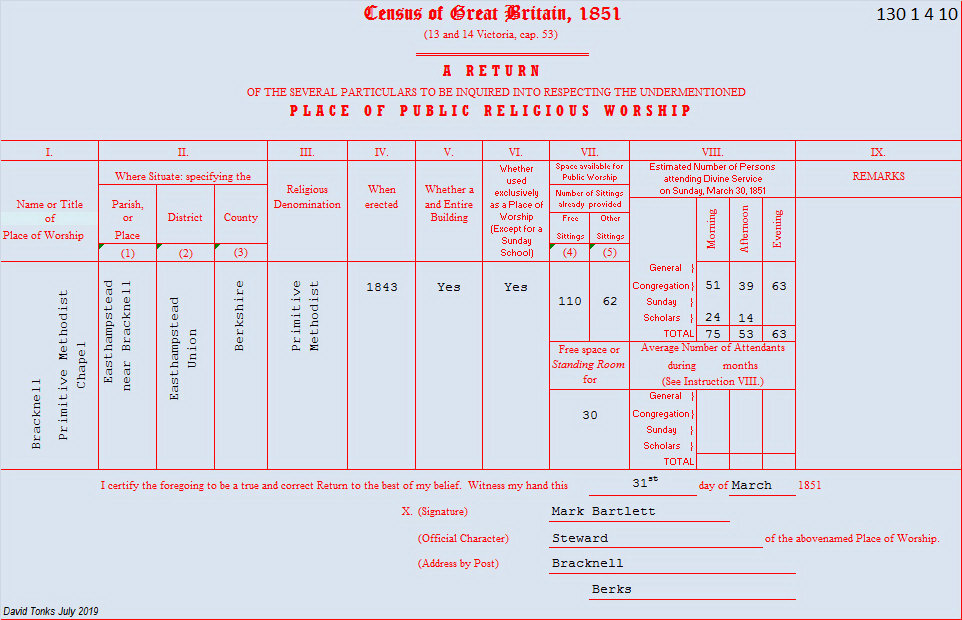
I wondered whether this location contradicted the detail in the 1851 Census of Public Religious Worship which locates the chapel in “Easthampstead parish near Bracknell”. Andrew provided the explanation:
The history of parishes in this area is slightly complicated. Warfield and Winkfield to the north, and Easthampstead to the south, are old settlements and appear in the Domesday Book. Bracknell did not appear until later and is not shown on a map until 1607. The settlement straggled the border between all three parishes, a situation not resolved until 1851 when the parish of Bracknell was formed. The area of Priestwood is immediately to the west of the town centre but has remained in the parish of Easthampstead, one of those bureaucratic muddles that was never sorted out.
Comments about this page
The chapel was registered as being in Easthampstead on 6th January 1844.
Berkshire Nonconformist meeting house registrations, 1689-1852, edited by Lisa Spurrier, Berkshire Record Society, Vols. 9-10, Reading: the Society, 2005
Birkshire Record Office :
ref. D/MS 24, Bracknell Primitive Methodist, (extent of documentation not stated in brief index).
Add a comment about this page